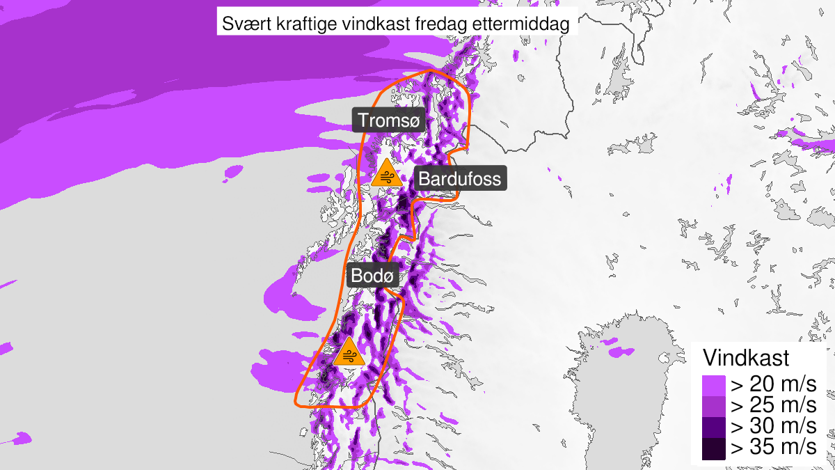
Warning from MET Norway for North-Helgeland, Salten, Ofoten and Troms
3
Very strong wind gusts ongoing, orange level (MET)
Published:
Valid:
from 22.01.2021 12:00
to 22.01.2021 18:00
Warning
Wind gusts
-
Sender: MET Norway
-
Danger ongoing: Friday, January 22, 2021, kl.12:00 PM
-
Danger decrease: Friday, January 22, 2021, kl. 6:00 PM
-
Certainty: Observed - 100%
Name
Frank
Consequence
Larger loose items may be taken by the wind. Risk of damage to buildings and infrastructure. Cancelled departures for ferry, plane, or other transport expected. Bridges may be closed. Many journeys may have longer travel times. The power supply will be impacted, due to tree(s) falling over. Roads may be closed due to trees or other objects in the road. Blowing snow causes reduced visibility and possibly convoys and/or closed roads. The strong wind may cause locally high waves in fjords and lakes.
Advice
Secure all loose objects. Avoid exposed places. Allow a lot of extra time for transportation and driving. Follow advice and check status from transport operators. The need for emergency preparedness shall be assessed continuously by emergency response actors. In advance consider measures to limit damage.
Description
Friday afternoon east and southeasterly storm is still expected, with locally very strong gusts with 30-40 m/s. The winds are first decreasing in the south, towards the evening also in the northern part. It has already been observed very strong wind gusts in the area, but large variations in wind speed are still expected. Some places may have calm conditions while other places experience very strong wind gusts. In addition the temperature at exposed places is in the range of -7 to -15 degrees. The combination storm and low temperatures could cause challenges for power delivery, there is potenial for frost bite and risk of moderate to severe icing on ships.