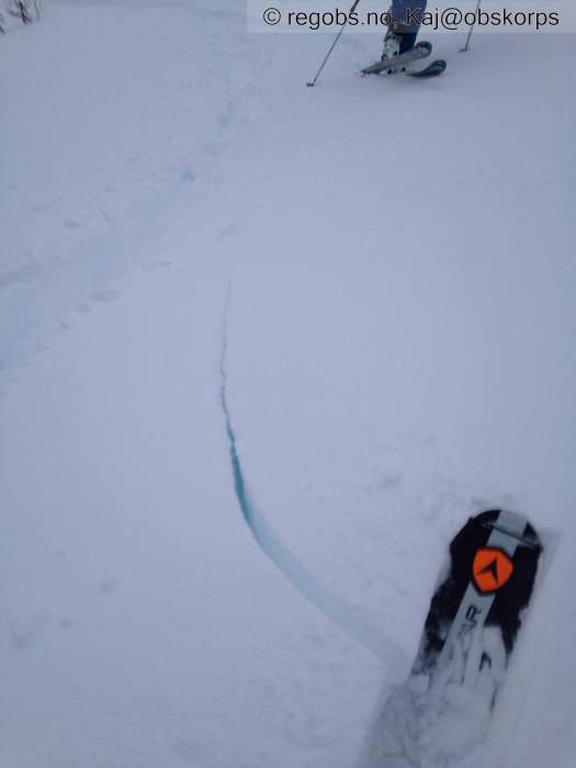
Image 1 of 9 Of: Danger Sign Copyright: Kaj@obskorps Comment: Ferske sprekker i fokksnø
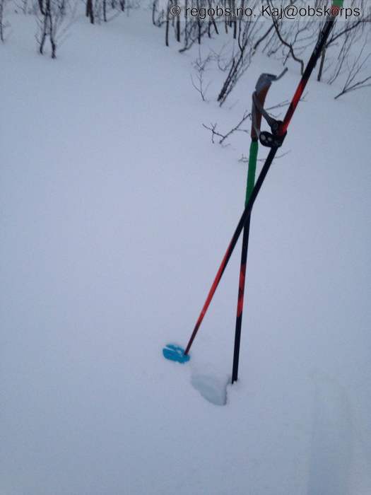
Image 2 of 9 Of: Snow Cover Copyright: Kaj@obskorps Comment: 30-50cm med fokksnø i leheng nær skoggrensen.
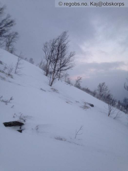
Image 3 of 9 Of: Snow Cover Copyright: Kaj@obskorps Comment: Svært vindpreget i høyden. Stor innsamling av fokksnø i leheng vendt mot N og Ø, og nesten avblåst på utsatt steder
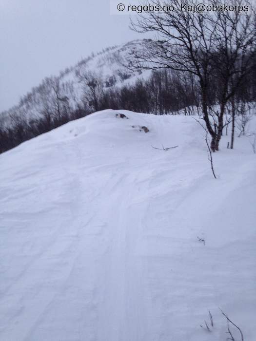
Image 4 of 9 Of: Snow Cover Copyright: Kaj@obskorps Comment: Svært vindpreget i høyden. Stor innsamling av fokksnø i leheng vendt mot N og Ø, og nesten avblåst på utsatt steder
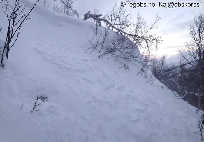
Image 5 of 9 Of: Avalanche Observation Copyright: Kaj@obskorps Comment: Testheng #2.
20m bred, 30cm dyp.
Str.1,5
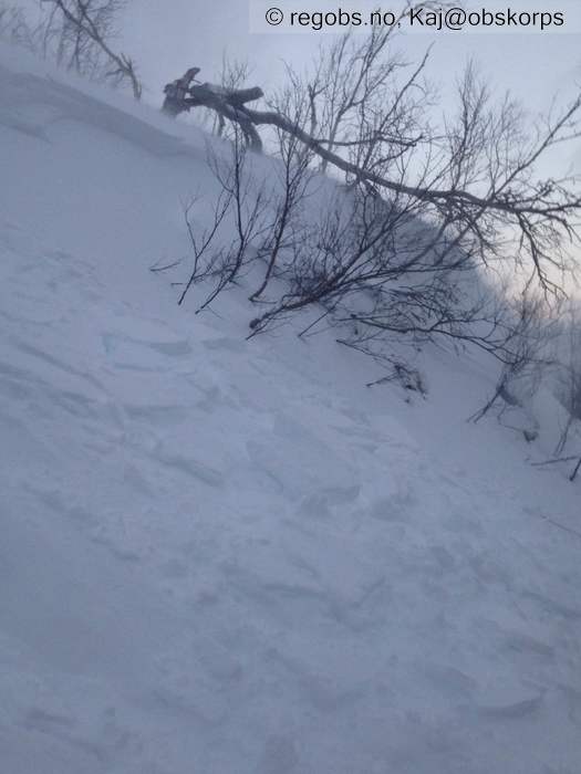
Image 6 of 9 Of: Avalanche Observation Copyright: Kaj@obskorps Comment: Testheng #2.
20m bred, 30cm dyp.
Str.1,5
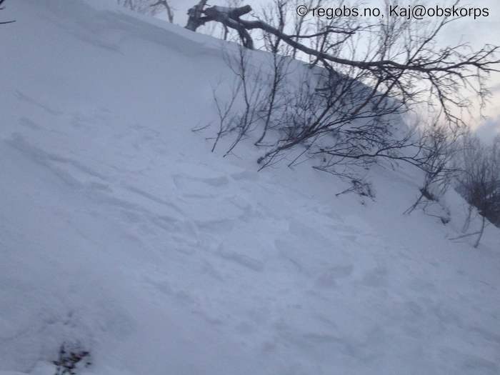
Image 7 of 9 Of: Avalanche Observation Copyright: Kaj@obskorps Comment: Testheng #2.
20m bred, 30cm dyp.
Str.1,5
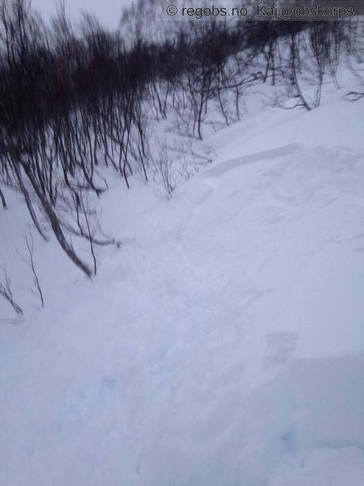
Image 8 of 9 Of: Avalanche Observation Copyright: Kaj@obskorps Comment: Testheng #1.
7m bred, 30cm dyp.
Str.1
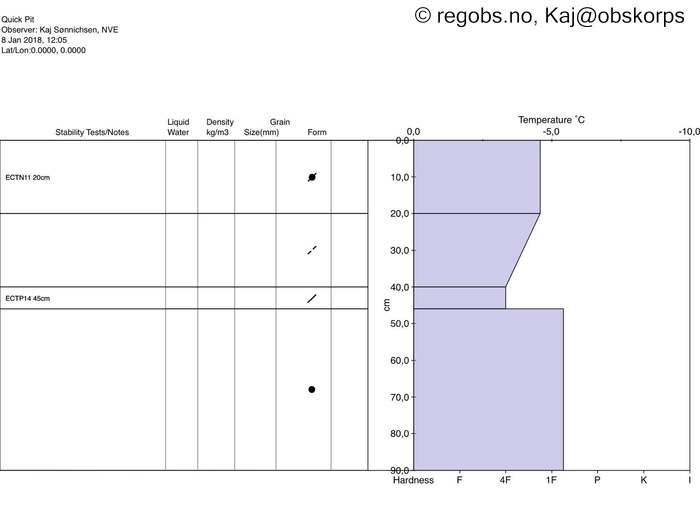
Image 9 of 9 Of: Snow Profile Copyright: Kaj@obskorps Comment: Snøprofil representativ av øvre del av snødekket i leheng vendt mot NØ ved tregrensen i kystnærstrøk.
Avalanche Observation
• 8. Jan 11:15 (+01:00) • Dry slab avalanche • 1 - Small • Artificial release test slope • NE-facing • Poor bonding between layers in wind deposited snow • 30 cm high and 20 m wide fracture • Lee side • 2x produktiv skicuts i testheng.
Incident
• Did not affect anything
Danger Sign
• Whumpf sound • Område: I denne fjellsiden. Beskrivelse: 1x drønn under skoggrensen (ca.300moh) kantkorn under MFcr fra 20.12
• Recent cracks • Område: Generelt på fjellet. Beskrivelse: Sprekker opp i fokksnøen
• Recent avalanches • Område: I denne fjellsiden. Beskrivelse: 2x produktiv skicuts.
Løser ut i fokksnø
• Recent snowdrift • Område: Fylket/varslingsregion. Beskrivelse: Sterk vind fra SV med stor innsamling av fokksnø i N og Ø vendt heng
Avalanche Activity
• 8. Jan. During the day (+01:00) • Dry slab avalanche • Few (2-5). 1 - Small. Easy to trigger • Some steep slopes. NE • 2x produktiv skicuts. Se "skredhendelse" felt.
Ingen andre observert- men det var veldig begrenset sikt på snaufjell.
Weather
• No precipitation • -4 °C • 12 m/s from SW ↗ • 80% clouds • Sterk vind under natt til mandag.
Også litt nysnø, ca. 5-10cm (vanskelig å anslå pga vind)
Snow Cover
• Moderate snow drift • 8 cm • Elevation of new snow 0 masl • Storm slab (soft slab) • Dry • Svært vindpreget i høyden. Stor innsamling av fokksnø i leheng vendt mot N og Ø, og nesten avblåst på utsatt steder. Snødekket har et tydelig "opp-ned" oppbygging med stivere fokksnø ovenpå mykere delvis nedbrutt krystaller.
Avalanche Problems
• Dry slab avalanche • Poor bonding between layers in wind deposited snow • Within half a meter • The weak layer collapses easily and clean (easy propagation). The collapsing weak layer is thin < 3 cm. The overlying slab is soft. • Easy to trigger • Likely • 2 - Medium • Some steep slopes N, NE, E, SE above 400 masl • Skredproblem #1.
Str.2 skred anses som sannsynlig med liten tilleggsbelastning.
Men også mulig som naturlig utløst.
• Dry slab avalanche • Buried weak layer of faceted snow beneath a crust • Within a meter • The weak layer collapses easily and clean (easy propagation). The collapsing weak layer is thin < 3 cm. A big and identifiable crystal in the weak layer. • Difficult to trigger • Unlikely • 3 - Large • Some steep slopes N, NE, E, SE above 400 masl • Mulig at vi vil ser noen "stepdown" skred på dette lag.
Det ligge nå forholdsvis dyp i snødekket og krever stor tilleggsbelastning for å påvirke det, men en skred i fokksnøen vil kunne overbelaste det. (NB! dette svaklag finnes i alle himmelretning, men den NØ sektor er mest utsatt siden det er dette område hvor det er forventet overbelastning i form av fokksnø).
Avalanche Danger Assessment
• En solid FG3 idag.
Sterk vind under natt til mandag har transportert mye snø inn i leheng og skapt et veldig tydelig og lett tolket skredproblem med fokksnø.
Testheng løste ut med liten tilleggsbelastning og det var flere skyttende sprekker. Dagens obstur gikk selvfølgelig ikke inn i skredutsatt område høyere opp på fjellet pga. skredfare, men med den mengde fokksnø som har blitt transportert det siste døgn er det forventet at det også har gått noen naturlige utløst skred.
Ved en kjapp profil gravde på 350moh (der hvor det var drønn) var det tydelig lag med kantkorn (1-2mm) under skare fra 20.12. Dette vedvarende svaklag ble ikke observert i snøprofil på 550moh men det var nok bare fordi det lå så dyp der hvor profilen ble gravde. • Ytterligere økning av skredfare forventet imorgen med ennå mer nedbør, vind og økende temperaturer. • 3 Considerable

